
 Printer Friendly
 Email to a Friend
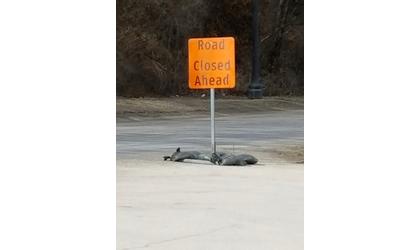
Road closed sign in place at Atchison's River Road due to flooding. (Credit: Cathy Scholz)
Credit: Nick Sherman of Platte City, MO
(KAIR)--As river levels remain high, officials continue to monitor the situation closely.
In Atchison, River Road remains closed, from the north Atchison city limits to the Doniphan County line.
The Missouri River, at Atchison, is expected to crest at 30.9 feet Thursday evening according to the the National Weather Service late Monday morning. That’s below an earlier prediction of a Tuesday crest at 31.8 feet. Flood stage is 22 feet. The highest recorded crest to date in Atchison was 31.63 feet on July 26, 1993.
Elwood city officials Saturday evening provided the residents of the Doniphan County city with an update regarding flooding.
Elwood City Attorney Joel Euler said, "Optimism or stay alert because what you're having is that the anticipated crest is going down—went down by about a foot and that's because things are happening north of us that aren't good for those folks, but beneficial for us," Elwood city attorney Joel Euler said.
Concerns of a possible evacuation have subsided somewhat, with the latest crest prediction forecast. The National Weather Service indicates the Missouri River, at Elwood, will crest at 28.1 feet Thursday morning. Evacuation would become mandatory at 30 feet. Flood stage at Elwood is 17 feet.
As a precaution, KQ2-TV reports efforts in Elwood include sandbagging and moving grades 3rd through 8th from Riverside USD 114, in Elwood, to Wathena.
Riverside Superintendent Bob Blair said the volunteer support has been generous. "We were overwhelmed by volunteers that brought trucks and trailers, people from both communities. We even had people from St. Joseph, Hiawatha, Atchison that came up to volunteer to help us out."
On Friday, Kansas Governor Laura Kelly issued a state of disaster emergency declaration for Doniphan County.
Meanwhile, the Kansas City District of the U.S. Army Corps of Engineers urges everyone to never drive through flooded roadways and to follow the slogan, “turn around, don’t drown.”
A news release issued by the Corps Sunday said that in the past week the Missouri River, and surrounding areas, have been experiencing a serious flood event. The high waters have been brought on by rapid snowmelt and rainfall upstream in the Nebraska and South Dakota region, as well as the breaching of two non-federal dams in northern Nebraska.
Flood waters are impacting county, state, and federal roads, bridges, trails, and recreation areas. Many areas have been closed, gated, or barricaded, and the Corps reminds those traveling near the Missouri River to double check the road conditions before driving.
Only six inches of fast-moving water can knock a person over, and it only takes 12 to 18 inches of fast-moving water to carry away most vehicles including large SUVs.
Credit: Nick Sherman of Platte City, MO
© Many Signals Communications
MOST VIEWED STORIES
Horton man arrested following weekend shooting
Hiawatha man facing sex, drug charges waives prelim hearing
Morrill pair arrested on drug, child endangerment charges
Falls City man sentenced to Federal Prison
Two arrested Thursday in Jackson Co on meth-related charges
Jackson Co traffic stop leads to arrest
Ground Broken for new Sac and Fox Trad'n Post
One held for past Atchison shooting
Inmate dies at Lansing Correctional Facility
Early Thursday storms leave damage, outages, locally
Jackson Co crash confirmed as fatality
MO grass fire battled Thursday
Mound City Mayor Duane Nauman remembered
Community Healthcare System hires new CEO
Brown Co Planning Commission established
Falls City School Board approves personnel moves and purchases
Valley Falls' future set for Wednesday eve discussion
LATEST STORIES
Jackson Co crash confirmed as fatality
90 mph+ downburst winds blamed for Thursday damage
Morrill pair arrested on drug, child endangerment charges
Rates to increase at Brown Co landfill
NOAA weather radio event set in Seneca
Falls City man sentenced to Federal Prison


Hiawatha, Ks 66434