Posted April 30, 2024 03:18pm
(KLZA)-- THE NATIONAL WEATHER SERVICE HAS EXTENDED TORNADO WATCH 163 TO INCLUDE THE FOLLOWING AREAS UNTIL 10 PM CDT THIS EVENING. IN NEBRASKA THIS WATCH INCLUDES 6 COUNTIES IN SOUTHEAST NEBRASKA: GAGE JEFFERSON JOHNSON NEMAHA PAWNEE RICHARDSON THIS INCLUDES THE CITIES OF AUBURN, BEATRICE, FAIRBURY, FALLS CITY, PAWNEE CITY, STERLING, TABLE ROCK, AND TECUMSEH.
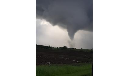
More strong to severe storms are occurring this afternoon and
evening across portions of eastern Nebraska and southwest Iowa.
Large hail up to 3 inches in diameter and damaging winds up to 75
miles per hour are the primary threats. A few tornadoes will also
be possible. The greatest severe weather threat will be through 8
pm.
More storms are expected beginning Wednesday afternoon and
continuing through Wednesday night into Thursday morning. The
greatest severe weather threat will exist near the Kansas border,
while the potential for flash flooding will encompass a larger
part of eastern Nebraska and southwest Iowa.