Posted April 19, 2024 01:02pm
(KAIR)--Thunderstorm downburst winds reaching up to 100 mph are blamed for this week's damage following severe thunderstorms that ripped through the area early Thursday morning.
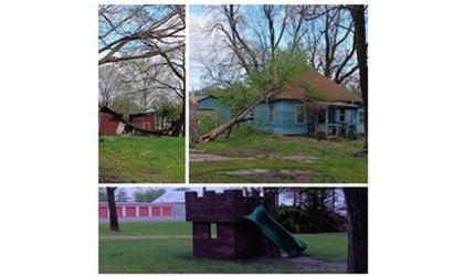
Areas of Jefferson County were heavily impacted, with the County Emergency Management Office reporting that Nortonville and Valley Falls were hit the hardest, with roofs torn off, outbuildings destroyed, trees uprooted, and power lines knocked out.
Nortonville residents, sharing photos and videos of the storm's aftermath with MSC News have also expressed shock at how, in Nortonville for example, one part of the community could incur such damage, while just blocks away, signs that a storm had even occurred were minimal.
Storm damage assessments have been made, with Chad Omitt, Warning Coordination Meteorologist for the National Weather Service in Topeka, telling MSC News there were "numerous pockets of enhanced damage due to thunderstorm downburst winds." He estimates that winds in Jefferson County reached 70 to 90 mph, along with possible isolated higher gusts.
According to Omitt, the strongest of the winds during the local Thursday morning storms are estimated to have reached 80 to 100 mph on the south side of St. Marys, in Pottawatomie County, where damage was also incurred.
The storms rolled through the area sometime after 2:00 Thursday morning.
Omitt, in Friday's emailed correspondence with MSC News, explained that thunderstorm winds, or downdrafts, are also known as downbursts, and, or, microbursts, depending on how large an area is impacted.