
 Printer Friendly
 Email to a Friend
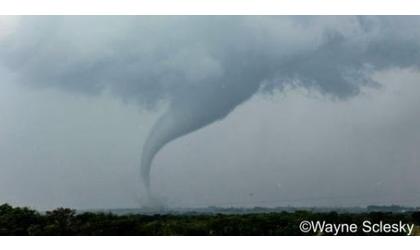
Reserve area tornado ( Credit: National Weather Service)
(KNZA)--Severe storms moved through northeast Kansas Friday evening producing at least two confirmed tornadoes.
The National Weather Service said a tornado touched down four miles southwest of Reserve in Brown County at 7:03 pm.
The tornado traveled 1.2 miles, with a maximum width of 500 yards. It was on the ground for 9 minutes.
A team from the Weather Service surveyed damage Saturday. Damage was found to a home north of Hamlin.
The Weather Service rated the tornado an EF-2, with wind speeds up to 112 miles an hour.
Another tornado touched down north, northeast of Holton in Jackson County at 7:11 pm.
The Weather Service said the tornado traveled 3.5 miles, with a maximum width of 50 yards. It was on the ground 9 minutes.
A survey team determined it was an EF-1 tornado, with winds speeds up to 90 miles an hour.
The Jackson County Sheriff's Office said damage was reported to some outbuildings, with at least two barns and sheds destroyed.
No injuries were reported.
© Many Signals Communcations
MOST VIEWED STORIES
Missouri River flood warning update
Ex-Pawnee City School para sentenced for sex abuse
Four arrested after Jackson Co traffic stop
BB guns, fireworks, all off limits in Atchison
Sunday wreck injures one in Atchison
Convicted baby biter sentenced to prison
New Hiawatha City Adminstrator hired
Morrill welfare check ends with drug arrests, children removed
Housing to expand through Atchison Main Street funds
Tax credits awarded to two local non-profits
Flood dangers realized by Falls City driver
Pilgrims arrive in Atchison Tuesday; KDOT closes lane for arrival
Ribbon cutting ceremony held for new Seneca fitness court
Monet's Garden comes to life in Atchison
Outgoing Holton USD 336 Supt. recognized
Jefferson Co's squatting ban moves forward
At risk teen missing in Atchison; public asked for help
Flooding expected along Missouri River
LATEST STORIES
Commission discusses KDOT letter on street lights
At risk teen missing in Atchison; public asked for help
IDOT recommends detour from I-29 if flooding occurrs
Pilgrims arrive in Atchison Tuesday; KDOT closes lane for arrival
Flood dangers realized by Falls City driver
Autopsy awaited in inmate's death
Morrill welfare check ends with drug arrests, children removed
Jefferson Co RWD#10 under boil advisory


Hiawatha, Ks 66434