 Printer Friendly
 Email to a Friend
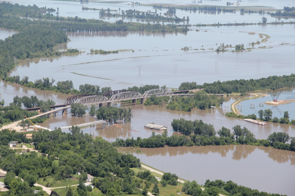
(KLZA)-- A flood warning is now in effect through Tuesday, July 2 along for the entire length of the Missouri River below Gavins Point Dam in South Dakota.
On Monday, the Atchison County, Missouri Emergency Management Director Rhonda Wiley issued a release which stated the Atchison County Levee District #1, Buchanan Levee District and Northwest Atchison Levee District have recommended the removal of grain and equipment from the Missouri River bottom as soon as possible. Levees are new, untested and are considered vulnerable. The most critical time frame will begin Wednesday and last through Monday, July 1.
Atchison County levees are being patrolled by the Atchison County Sheriff's Office and the Missouri Department of Conservation. Unauthorized persons caught on the levee system will be prosecuted to the fullest extent of the law.
Heavy rains are expected Thursday through Friday night that could cause more severe flooding and prolong the flood conditions.
Moderate flooding is forecast for the Rulo, Nebraska area with a river crest forecast at 24 feet early Saturday afternoon. That is 7 feet above flood stage at Rulo.
At Brownville, the Missouri River is predicted to crest Friday evening at 42.7 feet. Flood stage is 34 feet with major flooding occurring at 43 feet.
At Nebraska City the forecast is for the river to crest Thursday evening at 25.3 feet, more than 7 feet above the 18 foot flood stage.
Downstream at St. Joseph, Missouri, the crest is forecast at 24.4 feet Sunday morning, June 30 which is nearly 7.5 feet above the 17-foot flood stage.
The river forecast for Atchison, Kansas is for a crest of 24.8 feet, 2.8 feet above the 22-foot flood stage on Monday morning.
Nebraska Governor Jim Pillen and Iowa Governor Kim Reynolds issued a joint request Monday for people to remain off the Missouri River in the coming days, as water levels continue to surpass flood stage.
In addition to higher-than-normal flow, there is also the potential for more debris in the water, which poses a significant risk to anyone on the Missouri River.
Pillen says he is comfortable that the rebuilt levies will protect important sites along the Nebraska side of the river, including Offutt Air Force Base south to the Cooper Nuclear Station near Brownville.
The Iowa Department of Transportation will close part of Interstates 29 and 680 by midday Wednesday ahead of the floods expected crest in the Omaha area.
The rise in the Missouri River level is being caused by heavy weekend rains in southeast South Dakota, northeast Nebraska and northwest Iowa. Much of the rainfall is draining into rivers that enter the Missouri River below Gavins Point Dam which is the southernmost control structure on the river.
© Many Signals Communications
MOST VIEWED STORIES
Missouri River flood warning update
Sunday wreck injures one in Atchison
New Hiawatha City Adminstrator hired
At risk teen missing in Atchison; public asked for help
Pilgrims arrive in Atchison Tuesday as part of natl walk
Morrill welfare check ends with drug arrests, children removed
Local radio group welcomes new GM
Flood dangers realized by Falls City driver
Commission discusses KDOT letter on street lights
AT&T: Atchison internet outage due to contractor accident
Jefferson Co's squatting ban moves forward
Woman arrested in Holton after suspicious activity report
Flooding expected along Missouri River
Flood not expected to reach same levels as 2019
KDHE: Residents, pets, told to avoid flooding MO River waters
Falls City woman arrested on felony drug charge
Autopsy awaited in inmate's death
Pyle: Kelly to hold ceremonial signings in Brown and Jackson counties
Bench trial held for man charged in fatal 2022 Jeff Co crash
LATEST STORIES
Pyle: Kelly to hold ceremonial signings in Brown and Jackson counties
Local firefighters gain from KS insurance funding
Toxic Algae alert for Kirkman's Cove Lake
Hiawatha fireworks ban to remain in place
Woman arrested in Holton after suspicious activity report
Bench trial held for man charged in fatal 2022 Jeff Co crash
AT&T: Atchison internet outage due to contractor accident
KDHE: Residents, pets, told to avoid flooding MO River waters


Hiawatha, Ks 66434